Built by anglers · For anglers

Know the water
before you go.

Every public fishing water in Illinois and Iowa — with the stocking reports, live river levels and depth maps anglers usually dig out of government websites one page at a time.
1,400+
public waters
2
states, one map
4,000+
stocking records
180+
DNR depth maps
What's in the vest

Everything but the bait.

One app that does the homework for your whole trip — where to go, what's in there, and whether it's worth hooking up the boat.
🗺️

Every public water, mapped

1,400+ lakes, ponds and rivers across both states, with boat ramps, fishing piers and shore access. If it's on the map, you're allowed to fish it.

🐟

Stocking reports & alerts

What the DNR actually put in — species, counts and waters, from both states' records, refreshed automatically. Know about the walleye before the crowd does.

🌊

Live river levels

USGS gauges on every major river, read in plain angler terms — stage, flow and whether it's rising — before you drive out.

🧭

DNR depth maps

Real bathymetry on 180+ lakes. Find the channel, the flats and the drop-offs without a $2,000 graph.

🎯

Best Water & bite forecasts

A daily top-five for your home state and species-by-species feeding windows built from moon, pressure and season.

📖

A catch log that learns

Log a fish in seconds — the app tags the water and conditions automatically, then shows you your own patterns. Private groups for your fishing crew, no public feed.

Try it right here

Take it for a cast.

A working preview of the app, right in your browser — built with the same Illinois stocking records and lake data the real thing runs on.
  • Tap the tabs along the bottom, like the real app
  • On the map, tap a gold pin to open the water's file
  • Filter the stocking list by species
  • Log yourself a crappie — it takes about four seconds
Get the real thing — free
Interactive mock-up of the early-access app. Stocking counts, depths and waters are the app's actual IDNR records; weather and river conditions shown are a sample day — the app reads them live.
6:04📶 🔋
Good morning 🌅
Tuesday, October 6
Today's best water
Kinkaid Lake — Jackson Co.
Deep, clear highland reservoir. 55,028 walleye stocked last year, and the fall bite is on the rocky points.
WalleyeMuskie81 ft max
Bite forecast
Prime window: 6:12 – 9:40 AM
Falling pressure ahead of the front + waning moon. Good and getting better.
Your rivers
Big Muddy River at Murphysboro
Stage steady · fishable · live from the USGS gauge.
Stocking alert
82,047 largemouth → Crab Orchard
IDNR's 2026 stockings are on record. See what went in near you.
Big Muddy River Kinkaid Lake Crab Orchard Lake Devils Kitchen Lake SOUTHERN ILLINOIS · TAP A PIN
Stocking
Southern Illinois · IDNR records
Catch log
Yours. Private. It learns your patterns.
🐟
Black Crappie · 12½"
Crab Orchard Lake · brush pile
OvercastWind SW 6Auto-tagged
🎣
Channel Catfish · 24"
Big Muddy River · cut bait
Stage 4.1 ftDuskAuto-tagged
Logged in 4 seconds ⏱
The data is the app

The state publishes it.
Almost nobody reads it.

Stocking records, fish surveys, trout programs, river gauges — it's all public record, scattered across government sites. Stringer Pro pulls it into one place and keeps it current.
82,047
largemouth stocked in Crab Orchard Lake this year
33,630
walleye into Wolf Lake — did you know?
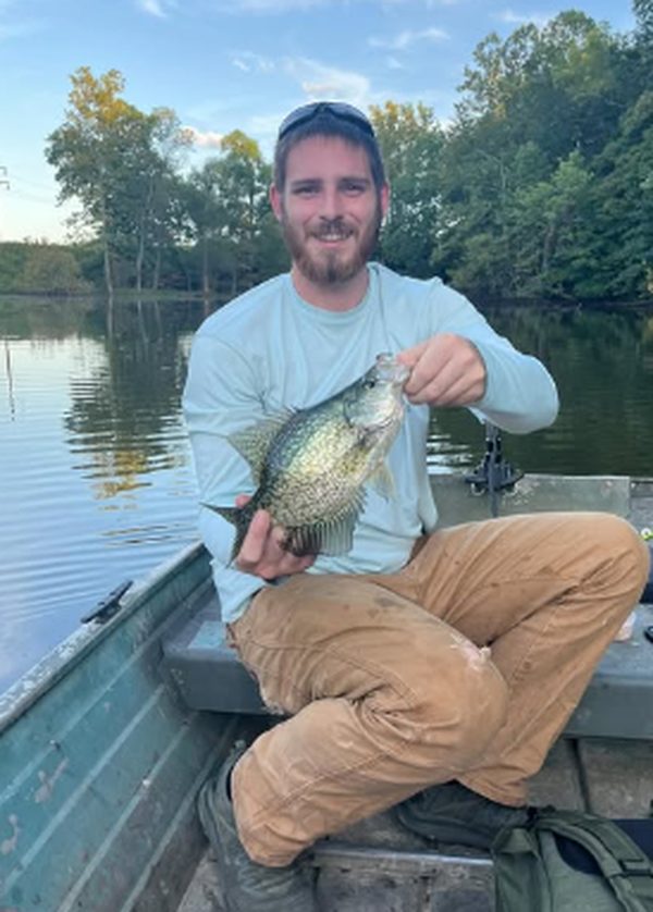
Taylor Streeter holding a crappie
"Slab crappie — logged in 4 seconds."
Built on the water

Made in DeSoto, Illinois — not a boardroom.

Stringer Pro is built solo by Taylor Streeter, an angler from Jackson County who got tired of digging through DNR websites before every trip to Crab Orchard, Kinkaid and the Big Muddy.

The rules are an angler's rules: only genuinely public water makes the map — about a hundred ponds were cut because the public couldn't legally fish them. Regulations are never behind a paywall. And there are no ads and no trackers — the privacy policy fits on one page and means it.

The crappie on the badge? That's a real one, from a real jon boat, on water that's in the app.

New · Iowa just joined the map

Two states.
One field guide.

900 Iowa lakes, 158 rivers and trout streams, 960+ boat ramps and 180+ DNR depth maps — alongside everything Illinois. Fish across the river without switching apps.
Fish both states free